
Decatur, Alabama – 3-GIS, an Alabama based software development and services company, has launched Buzz, a mobile viewing solution designed specifically for BlackBerry® smartphones.
Using Buzz, first responders have the ability to quickly access detailed information about resource availability and critical infrastructure. Developed to utilize the ESRI ArcGIS Server technology, Buzz allows the user to locate crews and verify the status of safety sites such as shelters and hospitals. Buzz is also equipped with photo capture functionality, allowing the first responder to take a photo with the Blackberry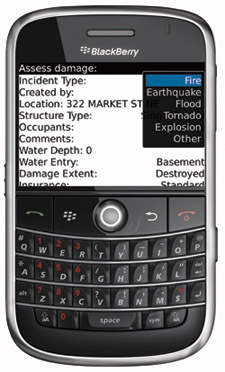 Smartphone’s camera then post back detailed information about the photo giving the emergency operating center real time access to the common operating picture.
“BlackBerry smartphones have such a significant presence in the emergency management marketplace,” says Tom Counts, president of 3-GIS. “We recognized that there is a large unaddressed user-base in this market that is fully committed to the BlackBerry platform. We designed Buzz to meet the needs of these customers without the requirement of additional hardware.”
About 3-GIS 3-GIS is a premier GIS software development and services company. The company provides customized software and solutions to a variety of companies in the Utilities, Telecommunications and Emergency Management markets. 3-GIS builds, interfaces, and integrates many diverse asset management systems, work management systems, analysis packages and other specialized software. 3-GIS offers the Express Solution, an ArcGIS Server-based suite of thin-client asset management products. For more information, visit www.3-GIS.com.
For more information, contact: Amy L. Garrison Phone: 256-560-0744 x 245 Email: agarrison@3-gis.com